The Valley of Ten Thousand Smokes
Quick Facts:
Drive time from Brooks Camp: 2 hour bus ride, reservations available here
Mileage: ~25 miles, out and back
Elevation gain: ~3,000 feet
Activity: Backpacking
Estimated time: 3-4 days

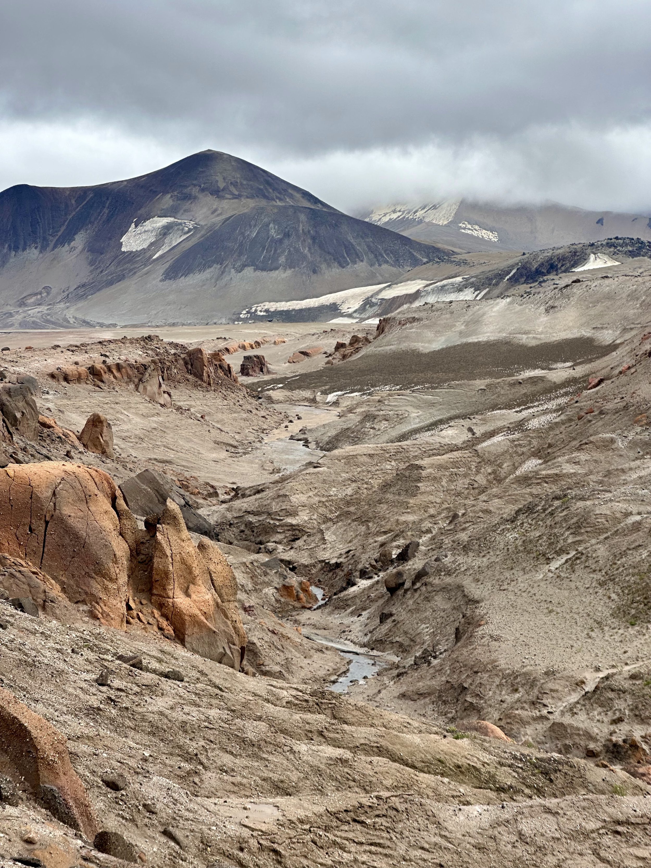
This was one of the most jaw-dropping places I’ve ever been. The Valley of Ten Thousand Smokes is the site of one of the largest volcanic eruptions of all time, and it exists within Katmai National Park. Katmai is known for its bears and wildlife-viewing opportunities, but there’s so much more to the park. First, I want to talk about the logistics of this trip as there’s a lot required, and then we can talk about our backpacking route throughout the Valley of Ten Thousand Smokes.
The Logistics:

To get to Katmai National Park, we first flew on Alaska Airlines to King Salmon, Alaska. From King Salmon, we took a floatplane to get to Brooks Camp within Katmai National Park. We flew with Branch River Air Service as there were 6 of us, so it was more affordable to split the cost of one of their planes. They picked us up from the airport and shuttled us to their dock, where we were able to borrow stove fuel and bear spray, as these aren’t allowed on commercial airlines. From there, it was only a 20 minute flight to Brooks Camp.
We camped within the electric bear fence at Brooks Camp for our first night at Katmai for $18/person. Reservations are required for this, and they open at the beginning of January. We were unable to get permits at first, and I checked every single day looking for cancellations. One by one, we were able to get permits as people cancelled throughout the year, and we found that there were a ton of cancellations the week before our trip, so don’t give up hope! At Brooks Camp, you can also find stove fuel that people have left behind. We spent the evening walking around the elevated platforms and Brooks Falls to look at bears.


The next morning, we stopped at the visitor center to give them our route plan and check the weather for the weekend. Winds were gusting and it was pouring rain at Brooks Camp, and the rangers nearly talked us out of going on our backpacking trip as weather is often worse in the Valley of Ten Thousand Smokes. However, they informed us that there’s an emergency shelter to sleep in at the Three Forks Visitor Center at the start of the Valley if needed, so we decided to take the risk. We met our tour bus driver at 8:45am to take us out to the Valley, and the tour makes a couple of stops and provides history throughout the 2-hour ride. The bus will offer to drop you off at the Windy Creek trailhead about 1/2 mile before the visitor center, but due to the weather, we opted to ride all the way to the visitor center to eat lunch and wait out the rain. Lucky for us, it stopped for the whole weekend!

The Backpacking Route:

We walked 1/2 mile down the road from the Three Forks Visitor Center to the Windy Creek trailhead to start our hike. The trail descends through some thick brush for a little over a mile until you get to Windy Creek. There was a decent amount of cow parsnip on the trail which can be painful on the skin, so we all wore rain paints and rain jackets to be safe. At Windy Creek, you may lose the trail when finding a safe place to cross, but that’s okay as it’s easy route finding after the fact. We ended up crossing where it was about shin deep. After Windy Creek, you lose the vegetation and get immersed into the super flat, Mars-like terrain.

We kept bouncing on and off the trail getting distracted by the deep canyons and pumice rocks. Trail or no trail, keep heading towards the Buttress Range, as you’ll want to hike along the east side of it. Eventually, you’ll get your first view of the River Lethe, and its deep canyons will blow your mind. Continue walking in between the River Lethe and the Buttress Range until you find a large inlet in the Buttress Range. This area is called Six Mile and is a popular camping area due to its freshwater source and protection from the wind. Our legs were still feeling good, so we opted to walk another mile or so to another inlet/dried creek bed that had 2 waterfalls cascading into it. It was in a gulley with 2 steep sand banks on each side, so we were protected from the wind. We also had beautiful views of Mt. Griggs and found a ton of fossils.


We opted to use the campsite as a base camp and spend both nights out there, so Saturday was spent day hiking. We all continued hiking along the Buttress Range towards Mt. Mageik, admiring the views of the glacier. Eventually, the group split in half and the ladies hiked towards Mageik Lakes while the guys summited Mt. Cerberus.

Mageik Lakes (~12 miles roundtrip from our campsite):
We waited to cross the River Lethe until we were at its headwaters at the western Mageik Lake, aka the brown lake. Due to its color and the glacial flour, it’s really hard to tell the depth of the river, and the canyons in this Valley tend to be very deep. Make sure to use hiking poles and keep your backpack unbuckled when crossing. We spent 15-20 minutes walking up and down near the headwaters and turned back a few times, but we eventually found a crossing point that was about knee deep. This was by far the coldest water that we crossed on the whole trip, and the river is pretty wide so you’re in it for quite awhile. After we warmed up a bit, we climbed up over the sand dune and were able to finally see the brown lake.


We then started hiking east towards the other Mageik Lake, aka the blue one. On the map, this appeared to only be about a mile, but it took us over an hour because we kept running into super deep canyons that we couldn’t pass. In hindsight, it would’ve been easier to walk back down the river and then up towards the lake, but we saw some of the coolest canyons and reddest rock during this part of the hike. There was another small creek crossing in between the two lakes, but we found a crossing where we could step on rocks and keep our feet out of the water. We finally arrived at a viewpoint above the blue Mageik Lake and slid our way down to its shore.

After walking around the blue lake, we started following the river back down to the valley. The water was a beautiful blue the entire way and carved deep into the rocks. Once back at the valley floor, we were found another knee-deep crossing of the River Lethe. We then just meandered our way back to our campsite, admiring the colorful soil along the way.

Mt. Cerberus (~14 miles roundtrip from our campsite, 3,000 ft elevation gain):
The guys crossed the River Lethe earlier than us to start taking a more direct route towards Mt. Cerberus. They walked to its south side and started ascending that ridge. It took them way less time than I expected as it was never too steep. From the top, they were able to see Mageik Lakes, excellent views of the glacier, the ocean, the Trident Volcano lava flows, and views of Novarupta. They scree-skied down the northern side of the mountain and walked across the valley towards the River Lethe, where they were able to find a crossing narrow enough to jump across (although high consequence as it was likely incredibly deep in that area).


Although the hiking in the Valley is some of the flattest backpacking I’ve ever done, walking on sand all day can still tire out your muscles and make for some slow moving. Additionally, getting ‘cliffed out’ by sudden 50-feet deep canyons results in a lot of back and forth, so don’t try to rush miles on this trip. If we were to do it again, we would’ve done 3 nights out there to allow an additional day to hike to Novarupta.
We lucked out with perfect weather this trip, but that’s often not the case. It’s very common for strong winds to blow ash around the Valley, so we made sure to bring buffs and glasses to protect our eyes if need be. Also, this is still bear country, but we saw no signs of bears when we were out in the Valley. We did see wolf tracks though!

On our final day, we woke up and hiked the 7.5 miles back to the trailhead. The Windy Creek crossing was nice and warm compared to the river from the day before, but the hill after it was steeper than we remember. Once at the road, we walked back up the hill to the Three Forks visitor center to meet the bus by 2:30pm. We arrived back at Brooks Camp by 4pm, treated ourselves to a margarita at the Brooks Camp Lodge, saw some more bears, and spent another night at the campground before our floatplane picked us up the next day.
Final Costs per Person:
Roundtrip float plane to Brooks Camp: $390
Roundtrip bus ticket to Valley of Ten Thousand Smokes: $110
2 nights at Brooks Camp: $36
Blueberry rosemary margarita at Brooks Camp Lodge: $14
Grand Total: $550/person after flights to King Salmon (which were purchased with miles)