Mint-Bomber Traverse

Quick Facts:
Drive time: 1 hour from Anchorage
Mileage: approx. 20 miles
Elevation gain: ~5,600 feet
Activities: Backpack/ski
Estimated time: 3 days

We started this journey at the Gold Mint trailhead on Hatcher Pass, which has designated campsites for $15/night with fire pits and a couple toilets, so we slept at the trailhead the night before we started hiking.

Day 1 on the trail starts very gradually as you hike along the creek. There is a lot of brush on this trail so I could imagine it gets overgrown, but it wasn’t bad when we did this trail in late August. It was a rainy summer, however, which resulted in tons of mud on the trail. The trail is easy to follow until mile 6 where the trail is no longer maintained, but there was a social trail through the brush that we followed up to the edge of the valley.

You are climbing the final 2 miles of the trail to the Mint Hut. It’s pretty steep so expect to move slowly. Once you get to the knoll, make sure to take a right. The trail gets cliffy here, but this is still a better alternative than going up and around if you were to take a left.

It had started to rain the last mile, so we were very excited to be nearing the end of the climb and getting close to the hut. Take caution as the trail was very slippery when wet.

There are no reservations required to stay at Mint Hut, but it’s for MCA members only, so be sure to pay your $20 membership dues here prior to your trip: https://www.mtnclubak.org/membership

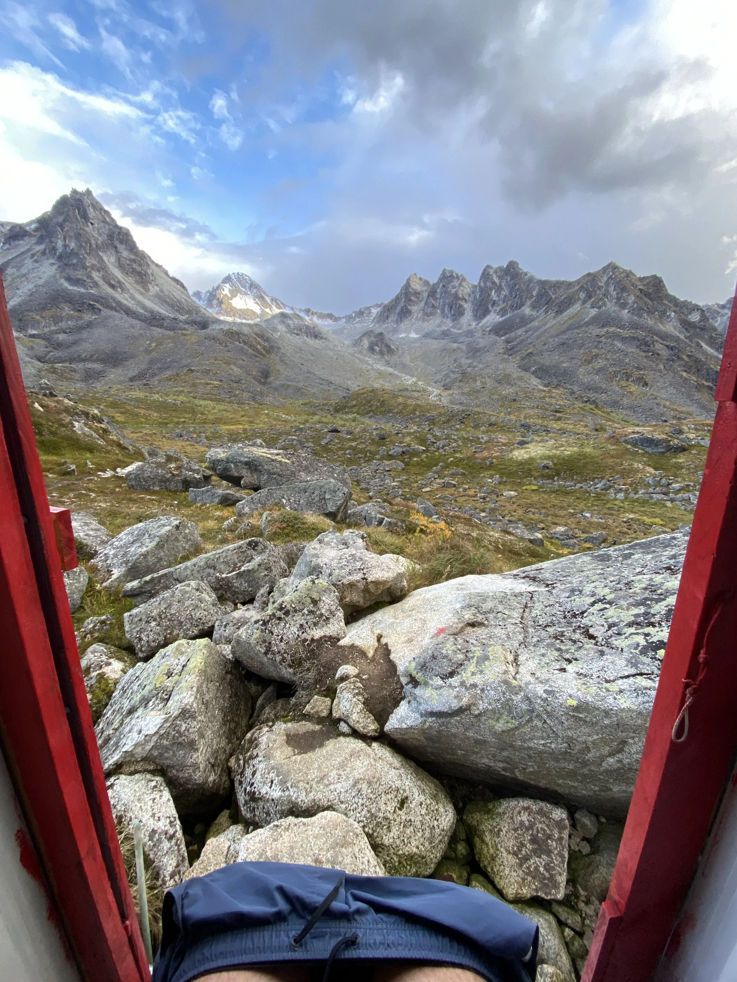
The view out the front door of the adorable Mint Hut.

The hut sleeps 8 people in the loft, but there were only 2 other people there the weekend we went. These huts are first-come, first-serve, so it might be wise to bring a tent in case they are full on a busy weekend. It was pretty cold in the hut, but it had lots of reading materials and emergency supplies available. There also is an outhouse. Be sure to leave a message in the guest book before you leave!

You could spend a weekend in the valley where the Mint Hut is located, but we decided to continue on our traverse over the Backdoor Gap (which is no joke). This is a 1,200 foot climb over scree and boulder fields to get over the pass into the next valley. Afterwards, we learned there may have been an alternate route up a chute to the right, but we took the left chute.

The dog and I were both anxious wrecks the whole time we were climbing towards the pass. The small boulders were rolling under our feet, and the big boulders required us to constantly climb down and back up. This was the first time I saw Hadley demonstrate a fear of heights, as she stopped jumping boulder to boulder once we were about halfway up. This added an additional challenge as Andy and I were having to lift her up onto the rocks.

The view from the top was well worth it! We ate a quick lunch and let our nerves settle before we started the descent on the other side.

This picture doesn’t do the climb down justice. There’s a fixed line that’s probably only 20 feet long, but it’s loose dirt and rock and very steep. There was no way Hadley was making it down, so Andy carried her (she didn’t love that part…). Once off the rope, we continued to descend down Penny Royal Glacier.

The glacier crossing was fairly chill, but I was wearing microspikes to be safe. There is a small crevasse at the bottom, but this was easily avoided by staying on the rocks to the right. Once down the steeper part of the glacier, we traversed across to the opposite ridge line, hiking down the valley on the left side of the creek.


The rest of the day is spent route-finding downhill through tundra that feels amazing under your feet after Backdoor Gap. There are a couple small lakes, and some mossy boulder fields along a creek until you see Bomber Hut off to the right.


Bomber Hut is another scene straight out of a movie. It is warmer and larger than Mint Hut, with two loft rooms for sleeping. The valley has a lot of creeks and ponds, making it a fun area to explore. The views are also hard to beat. Both of these huts are dog friendly, but please be sure to clean up after them.

This takes the cake for best poop view!

Day 3 is the hike out over Bomber Glacier. You start by hiking directly across the valley on tundra with some creek crossings until you get to the base of the glacier. Probably because it was earlier in the morning, but this glacier was much icier than Penny Royal. We were able to do it with microspikes, but crampons probably would have been better.


There is wreckage on looker’s left of the glacier from a B-29 plane crash in 1957. This is a short side trip that is well worth checking out before traversing right towards Bomber Pass.
Once you get to the pass, there is a fixed line to help climb up. Another difficult portion to do with the dog, as Andy had to pull himself up with one arm while carrying Hadley in the other. This was a very muddy section, making it pretty hard.

The mist from this cloud was not doing us any favors. Once you make it to the top, the hard work isn’t done. Descending from Bomber Pass consists of lots of scree and huge boulders. This took us way longer to get down than we had anticipated, which was a morale killer.

Once you get down to Upper Reed Lakes, you’ll find the trail again and you have about 4.5 miles to go. This is a heavily trafficked area, so the trail is pretty mazed out and extremely muddy, but just continue heading down the drainage.

Pretty waterfall in between upper and lower Reed Lakes.

Once you pass Lower Reed Lakes, there’s more boulder hopping back and forth over a creek, as well as a couple pretty waterfalls. You are losing elevation almost the entirety of the hike from the pass, but it flattens out for the last mile to the parking lot.

We popped out at the Reed Lakes Trailhead parking lot, and Andy was unsuccessful in his hitchhiking attempt, so ended up jogging the 3 miles to the Gold Mint Trailhead to pick up the car (thanks babe!), while Hadley slept in my lap. This trail was very physically demanding, a tad bit scary, required some technical skills, but overall AMAZING! I highly recommend this trail, but please be warned that it’s not for everyone. Although we did manage to do this safely with our dog, I don’t know if I would bring her if I went back. She’s well-experienced in the backcountry and is in great physical shape, but this definitely pushed her limits and wouldn’t have been possible if we couldn’t carry her through certain sections.
This traverse could be extended along to the Snowbird Hut, and this route is often done in the winter as a ski traverse.